Finland’s National Land Survey Empowers Field Mapping with QField
Company Name
In 2025, Finland’s National Land Survey (NLS) made a bold and visionary leap by launching MTTJ, an open-source topographic data production system built on QGIS, QField, and other open technologies. This landmark initiative makes Finland the first country in the world to adopt an open-source GIS environment for national-scale topographic data production.

In 2025, National Land Survey (NLS) made a bold and visionary leap by launching MTTJ, a fully open-source topographic data production system built on QGIS, QField, and other open technologies. This landmark initiative makes Finland the first country in the world to adopt a fully open-source GIS environment for national-scale topographic data production.
Developed over several years and officially rolled out in spring 2025, MTTJ gradually replaces legacy proprietary systems with a modern, efficient, and extensible solution tailored to NLS’s evolving needs — all while promoting transparency, interoperability, and long-term sustainability. As part of this open architecture, QField will play a key role , empowering field teams to collect and validate data efficiently, even in remote locations. Use of QField is being piloted over summer 2025 and will be gradually taken up for full production use towards the autumn.
“QField lets our field staff work smarter and faster, even in the most remote corners of Finland. It’s a vital part of our open-source geospatial infrastructure.”
— Jani Kylmäaho, Director of Development and Digitalization, National Land Survey of Finland
Throughout the development of MTTJ, the National Land Survey of Finland actively engaged with the QField project, contributing not only feedback and use cases, but also procuring for the development of new functionalities key to NLS use cases to QField core. This close collaboration ensured that QField evolved to meet the demanding requirements of national-scale field data workflows and continues to benefit the wider open-source geospatial community.
Built for Performance, Collaboration, and Openness
The new system supports 100–150 concurrent operators, integrates photogrammetry tools, and offers robust real-time quality assurance and job management features. The architecture is centered on QGIS, PostgreSQL/PostGIS , and a custom set of plugins and APIs designed to streamline workflows from aerial imagery to finished topographic data
Among its standout features:
- Task and conflict management tools directly within QGIS
- Workspace-based editing to prevent data collisions
- Tight integration with QField for field data collection
All core components were built with open-source principles in mind — and many will be shared with the global QGIS and OSGeo community.
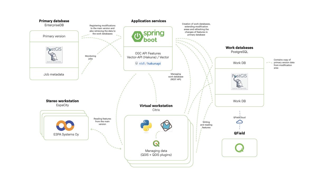
Seamless Field-to-Database Workflow
Finland’s mapping authority integrated QField and QFieldCloud to allow field staff and aerial image interpreters to:
- Collect and verify topographic features onsite,
- Access up-to-date maps and imagery offline,
- Digitize observations with domain-specific presets,
- Sync edits back to central databases using open standards.
This QField-enhanced workflow helps ensure high positional accuracy, real-time feedback, and consistent data quality , even when operators are far from headquarters.
Designed for Professionals, Chosen by a Nation
The NLS chose QField not only for its powerful offline capabilities and QGIS compatibility, but also because:
- It offers an intuitive user interface,
- It offers powerful functionalities,
- It enables field validation workflows,
- It’s adaptable, multilingual, and field-tested.
By integrating QField into a national strategy, Finland has showcased how modern, mobile-first open-source tools can outperform legacy systems — all while reducing costs and increasing flexibility.